Homewood Comprehensive Community Plan
An innovative neighborhood plan that incorporates the Nguzo Saba (Seven Principles) to transform Homewood into a desirable place to live, work, worship, and visit.
Pittsburgh Regional Transit (PRT)'s Wilkinsburg-Brushton Station Area Plan, the product of an 18-month long community planning process completed in 2023, identifies a need to reconfigure the Wilkinsburg Station park-and-ride property on the Martin Luther King, Jr. East Busway by:
We are building on PRT's planning work, the Homewood Community Plan, and the Operation Better Block Cluster Plans to shape the development that happens within a half-mile of the future Brushton Station.
We’ll collaborate with the community to create site plans for mixed-use and multi-family development on three sets of City-owned property near the Brushton Station site. DCP will work with partner agencies to establish policy and program recommendations tailored to each site, ensuring new development benefits the existing residents.
We’ll also look at opportunities to improve streetscapes throughout the neighborhood to ensure Homewood residents can safely access the Brushton Station. We’ll evaluate utility conditions to determine necessary upgrades for development and create preliminary recommendations for other properties. Lastly, we’ll explore policy and programs for the entire area to ensure Homewood South residents benefit from the station.
After the study, DCP staff will coordinate with other agencies and elected officials to implement the plan and find a development partner to build the site plan the community shaped with us.
Transit-oriented development (TOD) is a planning approach that builds dense*, mixed-use neighborhoods with homes, shops, and community spaces around strong public transit. TOD helps create walkable areas, allows more housing in smaller spaces, boosts transit use, cuts pollution, and makes it easier for people to live without needing a car.
* In planning, density is a way to describe how much is built or how many people are in a certain amount of space.For example, if a lot of homes, shops, and people are concentrated in an area, that area has high density. If buildings are spread far apart with fewer people living there, that area has low density.
In the Wilkinsburg-Brushton Station Area Plan, PRT proposes to shift the Wilkinsburg Station to the other side of the park-and-ride lot, closer to Downtown Wilkinsburg and the businesses / homes along Penn Avenue. Relocating the station closer to Downtown Wilkinsburg will make it much easier and more practical to use.
Shifting the Wilkinsburg Station closer to Downtown Wilkinsburg provides an opportunity to add a new station (Brushton Station) to serve the neighborhoods of Point Breeze North and Homewood South. Brushton Station will be placed between the existing Homewood Station and the relocated Wilkinsburg Station.
Right now, a large portion of Homewood South lies far from both the existing Homewood and Wilkinsburg stations. When Brushton Station is built, residents of this area will have a much shorter walk / bike / roll to reach the high-speed transit along the East Busway.
PRT is currently working on the design and engineering documents for the redesigned Wilkinsburg Station and the new Brushton Station. They are close to 30% complete with this task, and once PRT reaches this milestone, they will update community members with their progress. PRT is actively seeking funding for the construction of Brushton Station.
This study will directly build on the Homewood Comprehensive Community Plan's priorities and goals, specifically:
It will also be directly informed by the parcel-by-parcel land use vision created in the Operation Better Block Homewood Cluster Plans.
This will also be an opportunity to implement some of the projects that are in DOMI's Homewood Active Mobility Plan.
We will work with the community to create site plans and implementation manuals for mixed-use development on three specific sets of publicly owned vacant properties in the area within a 10-minute walk of the Brushton Station site.
City and PRT staff will hold two public design workshops to get a sense of what types of uses people would like to see on these sites. From there, we will work with an urban design consultant to create site plans based on the input we receive. Then, we will work with other City agencies and the Council District 9 office to transfer these properties to a developer that will build out the site plan the community created with us.
In addition to redeveloping sites, DCP will work closely with partner agencies to establish policy and program recommendations tailored to each site that will ensure new development benefits the people who already live in the area.
This study will be guided by the community priorities established in previous planning efforts such as the adopted Homewood Comprehensive Community Plan and the Homewood Cluster Plans.
Major investments in transit can lead to inequitable development patterns by contributing to rising housing costs. Good public transit is seen as a major "perk" that people want to live next to, which leads to demand for housing near transit rising and housing getting more expensive.
If not paired with thoughtful, community-driven planning, major transit investments can lead to people who have lived in neighborhoods for decades to suddenly get "priced out" of their neighborhoods. For example, when the East Liberty Transit Center on the East Busway was renovated, it directly led to housing prices increasing in the surrounding neighborhood.
Learning from this experience, we are going to proactively create a plan to ensure the new busway station benefits the neighborhood first. We would like to redevelop our properties into mixed-use development with public input so that the community has a say in what is built around the Brushton Station, before the station itself is constructed. We'd also like to look into policy and program recommendations that will allow existing residents to benefit from the station's construction.
We'll be combining a data-driven approach, looking at plans that have already been created for the area, and vetting them with the study's advisory committee.
After assessing the City's land holdings in the Brushton Station area, we'll be selecting sites for further study based on:
We will then run these sites past the study's advisory committee. From there, we'll present these sites at the first public design workshop to get ideas on what community members want us to do with these properties.
This study is jointly funded by the Department of City Planning and Pittsburgh Regional Transit. DCP staff are responsible for day-to-day project management because we are studying City-owned property. PRT is our primary agency partner because we are continuing planning work that they started. PRT can only plan for the station property itself, but the construction of the station itself will have impacts on the entire neighborhood, making partnership with the City necessary.
DCP and PRT are working with a multidisciplinary consultant team to execute this project. The consultant team will provide insight into the area's infrastructure, help us create site plans, and help us better understand the impacts of this new station on the surrounding community.
DCP staff will be working closely with the Homewood Community Development Collaborative and its member organizations for community engagement. The Homewood Collaborative helped us scope the study out. We will also work with Homewood residents throughout the course of the study to ensure that development in the station area reflects the community's vision, needs, and values.
Once the study ends, we'll work with the Department of Mobility and Infrastructure (DOMI), the Urban Redevelopment Authority (URA), the Department of Permits, Licensing, and Inspections (PLI), and the Pittsburgh Land Bank to prepare City-owned properties for development. We'll also be continuing to stay present in the community to provide updates after the project formally ends.
The City will leverage its own property holdings for mixed-use development. We would like to repurpose three sets of our vacant properties into a mix of housing at different forms (1-4 bedroom apartments, townhouses, etc), parks and open space, community-serving retail, neighborhood-serving businesses, and employment uses.
This aligns with general planning best practices for properties that have access to strong public transit.
We'd like to consult the community to learn exactly what that mix of uses will be and what buildings themselves will look like. We want to learn what types of housing the community needs, what types of businesses the community would benefit from, and what the neighborhood wants buildings to look like.
It is important for development near reliable public transit to consist of a mix of different things. Being able to develop different kinds of housing and businesses near reliable transit service makes it much easier to maximize the impacts of public transit.
The study's advisory committee consists of a combination of the following:
This committee's job is to make sure that development on City-owned property near the Brushton Station is both technically feasible and aligned with community priorities. This body will meet three times to provide oversight, input, and feedback at key milestones.
DCP will work with community organizations to plan two public design workshops for the study.
The first public design workshop will be structured as an interactive event where we'll invite participants to help brainstorm conceptual design ideas. We want input from community members to help shape what development could look like on vacant properties, and we want to know what the community wants us to do with these properties. We'll use the feedback from this first workshop to create draft site plans. which we'll present at the next workshop.
The second design workshop will be an open house for attendees to share their opinions on the draft site plans. We want feedback to refine the development proposal for each site. We want to make sure that the design concept that we create for each site aligns with what the community wants.
City Planning staff will ensure that the event is accessible for people who attend the design workshops in person. In advance of each workshop, we'll also try to understand if there are any language translation or ASL interpretation needs. Online versions of the workshop activities will be published on this page for folks who can't make it in person.
Yes! Recognizing that people have jobs and other commitments that may limit their ability to participate, we'll also build in opportunities for people to share their feedback with us both in-person and virtually.
These activities will include:
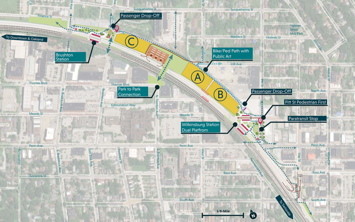
In the Wilkinsburg and Brushton Station Area Plan, PRT proposes to move the existing Wilkinsburg Station to the east end of the Wilkinsburg Park-and-Ride lot. The plan also proposes that a new station (the Brushton Station) be built on the opposite end of the Park-and-Ride.
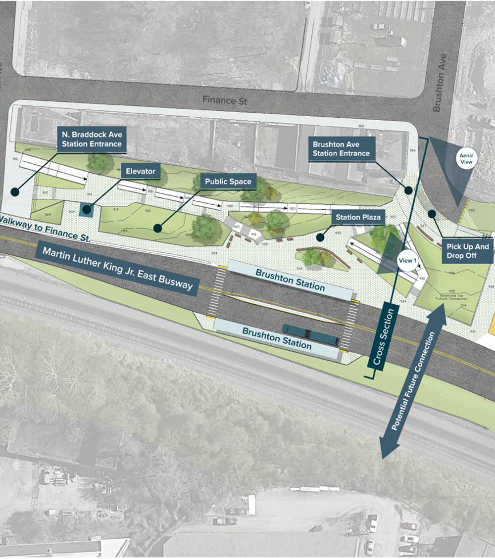
Conceptual design of the Brushton Station site as published in the Wilkinsburg and Brushton Station Area Plan
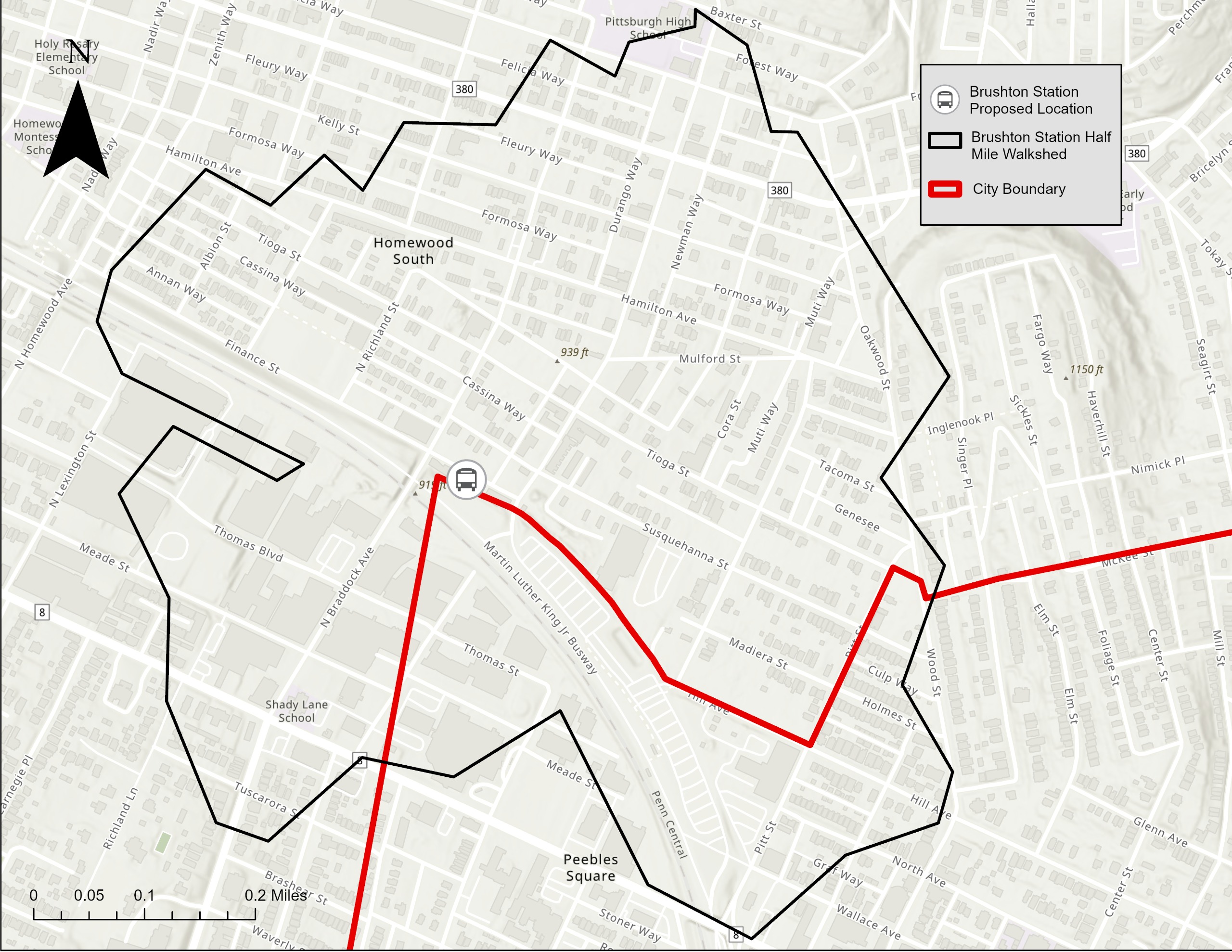
The Department of City Planning will be working with community organizations in Homewood to collaboratively design and redevelop three sets of publicly owned vacant properties within a ten-minute walk (approximately half of a mile) of the proposed Brushton Station site.
An innovative neighborhood plan that incorporates the Nguzo Saba (Seven Principles) to transform Homewood into a desirable place to live, work, worship, and visit.
This plan was created by PRT in 2023 and proposes a redesign of the Wilkinsburg Station on the East Busway by moving the existing Wilkinsburg Station to the east end of the Wilkinsburg Station park-and-ride lot and building the Brushton Station on the other end of the park-and-ride lot in Homewood South.
The Homewood Cluster Plans created a detailed land use vision for Homewood. They provide guidance for what should happen to vacant property, what types of development are right for different parts of Homewood, where houses should be renovated, mothballed or demolished, and where new businesses and parks should be located.
The URA created Bridging the Busway in 2012 as a community-driven planning vision for Pittsburgh's Homewood and Point Breeze North neighborhoods. This plan explores the potential for transit-oriented development around the MLK Jr. East Busway's Homewood Station.
This plan provides an in-depth analysis of transportation and mobility in Homewood. These findings were used to identify locations and types of mobility improvements and to prioritize those improvements based on community goals and input. This plan was created by the Department of Mobility and Infrastructure in 2022.
Wilkinsburg’s comprehensive plan provides a comprehensive plan, an in-depth review of the Borough’s business district and economic performance, and an internal look at the Borough’s operations.
This document is a formal evaluation of PRT's TOD work. This analysis found that while early transit-oriented development projects in the City successfully spurred growth near stations, they often failed to benefit the lower-income, transit-dependent residents most in need of improved access. The report emphasized that without stronger affordability measures and community input, TOD could undermine equity goals by pushing long-term residents farther from reliable transit.
The Homewood TOD Study evaluates past plans, current conditions, public input, potential development opportunities, land use, and public infrastructure to create a strategy to support new development around the existing Homewood Station on the East Busway
This study analyzes station access and infrastructure conditions at the existing Wilkinsburg Station and in the surrounding area. It also evaluates station area market conditions for development potential and available development sites.
To ask a question you must create an account or log in.
These are the people that are listening and responding to your questions.

Planner, Transit-Oriented Development
Department of City Planning
{{question.description}}
![]()


