Where are we now - Project Update 2023
DOMI constructed the Ellsworth Neighborway in Summer 2022, with the exception of the intersection Ellsworth at Devonshire. Additionally, will construct a neighborhood traffic circle, set back crosswalks, and construct new ADA ramps. This work will be done in Summer 2023.
Shadyside Connector Construction Complete
Project Background
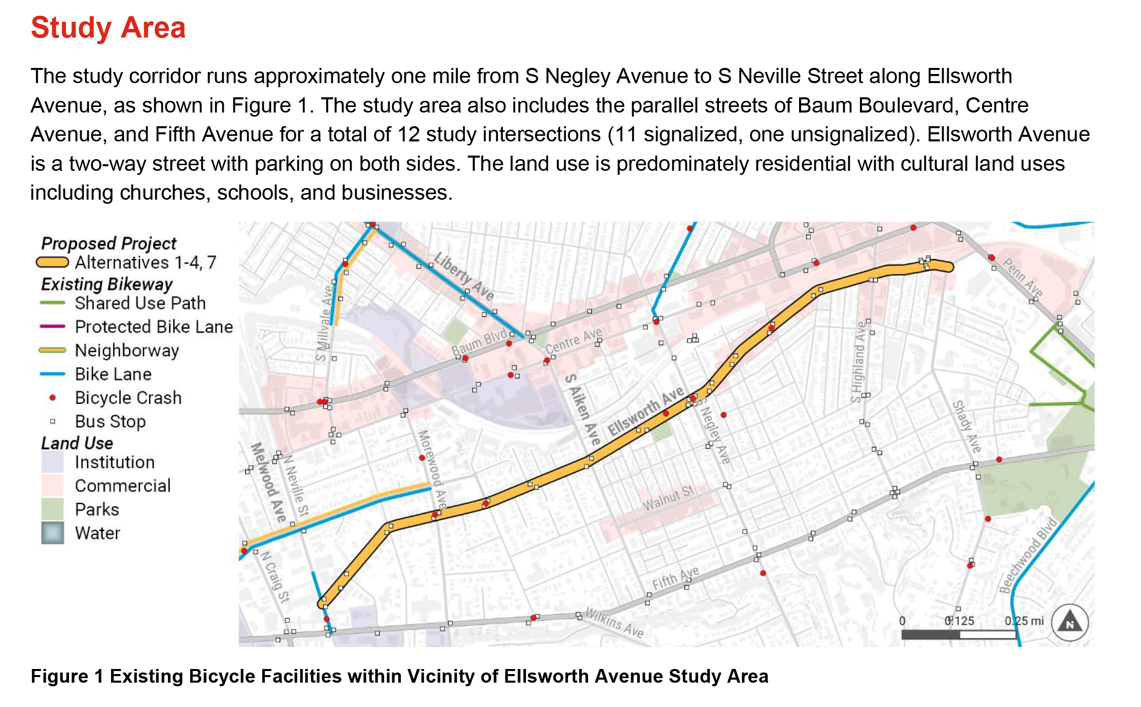
Originally recommended in the City’s 1999 Bike Plan, the Department of Mobility and Infrastructure (DOMI) began planning and designing the Shadyside Connector in 2018. To understand the corridor, DOMI studied traffic, walking, biking, and parking patterns to develop bikeway alternatives that would improve safety, connectivity, and usability along Ellsworth Avenue between North Neville Avenue and Shady Avenue.
Our project team studied each alternative to determine which option would best serve the community and meet project goals. To that end, we held a series of public meetings, pop-ups, and porch sits to gather input from the community and corridor users (see Project Process page for more information and links to meeting summaries).
After careful consideration, the City chose the Ellsworth Neighborway and has completed final design. To view the final design and construction plans, please click here. We thank everyone who participated and helped us get to this stage of design and we can’t wait to proceed with construction!

Chosen Design Concept: Neighborway

Following an analysis of all alternatives, we are moving forward with the installation of traffic calming, pedestrian improvements, wayfinding signage, and intersection improvements on Ellsworth, forming a Neighborway.
What is a Neighborway?
Neighborways are typically installed on streets with low vehicle volumes and speeds where bike riders feel comfortable sharing space with automobilities. To make bike riders feel comfortable, neighborways should have less than 3,000 vehicles per day and operate at 25 miles per hour or less. Since Ellsworth Avenue currently hosts 6,000-7,000 vehicles per day, converting it to a neighborway would require reducing vehicle volumes by 50-60%. Although significant traffic diversion was evaluated, it is not being pursued at this time. The Ellsworth Neighborway will maintain a higher than preferred volume of traffic for a shared lane and include frequent traffic calming elements to bring traffic closer to the speed of someone bicycling.
What is the Shadyside Connector?
Biking for recreation and transportation is common in Shadyside and a safe bikeway connecting Neville Street in Oakland to the neighborhoods of Shadyside and East Liberty was recommended for further study and included in the City’s 2020 Bike (+) Plan. The Shadyside Connector Project started in 2018 and evaluated options to identify, plan, and construct a safe bikeway through Shadyside. Since then, increased use of the corridor is spurring a fresh planning process to look at design and routing options connecting Oakland to East Liberty neighborhoods.
The Shadyside neighborhood streets are used by many people, from residents accessing their points of interest to those biking to connect between Oakland and destinations further east. The corridor is part of the overall Shadyside-Squirrel Hill Network of projects.
The Shadyside neighborhood streets are used by many people, from residents accessing their points of interest to those biking to connect between Oakland and destinations further east. The corridor is part of the overall Shadyside-Squirrel Hill Network of projects.
Sandwiched between the car-oriented Fifth Ave and the Baum/Centre corridor, Shadyside’s streets provide some of the better bicycling, pedestrian, and transit options in the city and it is part of the overall Shadyside-Squirrel Hill Network. Bicycle access, in particular, through the Shadyside neighborhood is important for connecting Oakland, home to many major employers and universities, with the neighborhood of East Liberty and the residential neighborhoods to the north and east. The neighborhood also provides an important link in the city’s MoveForwardPGH’s initiative of creating an 'All Ages and Abilities' bicycle network. For this reason, a safe bicycle connection through Shadyside is an integral component to the overall Shadyside-Squirrel Hill bicycle network.
Ellsworth Avenue, specifically, has been recommended as a bike connection for more than two decades when it was included in the City’s 1999 Bike Plan. Ellsworth Avenue is the most direct route connecting Oakland and East Liberty and has experienced some of the city’s highest bicycle volumes observed during annual bicycle counts and through third-party GPS services such as Strava. While the most direct and intuitive route, Ellsworth Avenue is narrow and the inconsistent parking utilization causes people riding bikes to merge in and out of moving vehicle traffic. This situation contributes to a higher risk of crashes and a chaotic, unpredictable environment for all users of the roadway.
Originally identified as a “high need” improvement in the 1999 Bike Plan, the City’s Department of Mobility and Infrastructure (DOMI) has been looking at this corridor for decades to see how to make it safer and accommodate more people. Through the MoveForwardPGH program, City staff worked with the community and smaller working groups to evaluate seven bike route alternatives based on directness, safety, traffic impacts, parking, transit operations, and feasibility. The current proposal includes reducing speeds on Ellsworth through traffic calming treatments.
How We Got Here
Project Origin
Pittsburgh Bike (+) Plan, adopted by the DOMI in 2020, sets ambitious goals for the City’s future bike network and bike ridership. A series of policies and projects are proposed as part of the Plan to support these goals. Specifically, the Bike (+) Plan outlined the goal of building a bike network that is a suitable level of comfort and safety for people of all ages and abilities. Designs appropriate for people of all ages and abilities should accommodate the majority of the population, particularly the “interested but concerned” population. Interested but concerned cyclists are people who would like to ride a bicycle but are uncomfortable riding along stressful roadways, are less comfortable riding along conventional, unprotected bike lanes, and are more inclined to ride on the sidewalk or not make a trip by bicycle if the route is too stressful.
In 2020 and 2021, DOMI led the installation of a series of rapid implementation bike network projects emerging from the Pittsburgh Bike (+) Plan. As part of this effort, called Move Forward, a safe and comfortable connection for biking through the Shadyside neighborhood was identified as a near-term priority. Shadyside’s streets are used by many people, from residents accessing points of interest to those biking to connect between Oakland and destinations further east.
In order to ensure all previous efforts were incorporated, these plans, as well as MoveForwardPGH’s initiatives and previous efforts were reviewed and relevant data and previous recommendation were evaluated.Data Analysis
To determine the best route for a bikeway through Shadyside, the project team looked at transportation, destination, and demographic data to evaluate every aspect of corridor and find the best possible solution.
These studies included:
- Origin and destination studies
- Traffic analysis Zones
- Mode shift areas
- Top Routes analysis
- Traffic diverter analysis
- Capacity analysis
- Traffic counts
- Intersection screening
Alternatives Proposed
Seven alternatives were evaluated.
Alternative 1: Ellsworth Ave Bike Lanes-Parking Removal
- Installation of protected bike lanes and bike lanes.
- Removal of all on-street parking.
- Management of bus/bike conflicts at bus stops required – either raised bike lanes at stops or gaps in the buffer so that buses can reach the curb.
Alternative 2: Ellsworth Ave Bike Lanes-Lane Removal
- Convert street to one-way.
- Diverted traffic shifts to neighboring streets and Baum/Center/5th.
- Remove one side of parking.
- Significant changes to all signals and intersection design/signage.
- Removal of one direction of transit and transit stops.
- Installation of protected bike lanes from Neville to Aiken and conventional bike lanes from Aiken to Shady.
- One side of parking removed between Neville and Aiken.
Alternative 3: Ellsworth Ave Neighborway
- Install traffic diverters at major intersections
- Diverted traffic shifts to neighboring streets and Baum/Center/5th.
- Removal of transit and transit stops in both directions.
- Installation of traffic calming elements and shared lane markings.
Alternative 4: Ellsworth Ave Advisory Bike Lanes
- Install traffic diverters at major intersections to cut traffic by a minimum of 30%.
- Diverted traffic shifts to neighboring streets and Baum/Centre/5th.
- Removal of transit and transit stops.
- Add advisory bike lanes.
- No changes to parking.
Alternative 5: Shadyside Neighborway Option A
- Install a contraflow bike lane on Castleman between Morewood and Amberson
- Install a contraflow bike lane on Pembroke between St James and S Aiken
- Install a contraflow bike lane on Elmer between S Aiken and S Negley
- Install protected bike lanes and remove parking on Aiken between Pembroke and Elmer
- Install crossing treatments at
- Morewood and Castleman
- Amberson and Castleman
- Amberson and Pembroke
- S Aiken and Pembroke
- S Aiken and Elmer
- Elmer and S Negley
Alternative 6: Shadyside Neighborway Option B
- Install a contraflow bike lane on Castleman between Morewood and Amberson
- Install a contraflow bike lane on Pembroke between St James and S Aiken
- Install a contraflow bike lane on Elmer between S Aiken and S Negley
- Install protected bike lanes and remove parking on Aiken between Pembroke and Elmer
- Install crossing treatments at
- Morewood and Castleman
- Amberson and Castleman
- Amberson and Pembroke
- S Aiken and Pembroke
- S Aiken and Elmer
- Elmer and S Negley
Alternative 7: No Build
- A no-build option on Ellsworth Ave will be used to compare the existing conditions to the proposed alternatives. There are some minor retrofits that could improve comfort for bicyclists on Ellsworth Avenue without significant cost/impacts. In particular, improved signage and intersection daylighting, which improves the visibility for all modes of transit by removing visual barriers within a minimum of ten feet of a crosswalk or intersection, could be implemented. This helps with reduce turning conflicts for vehicles and active transportation users.
Decision Making
The seven alternatives were evaluated based on safety, connectivity, and feasibility.
Safety – Alternatives that minimized uncontrolled crossings of busy streets and reduced the level of stress that would be experienced by someone bicycling were weighted higher in the evaluation.
Connectivity – Alternatives that increased connections to transit stops, parks, schools, existing bikeways, and commercial destinations were weighted higher in the evaluation. The team also evaluated each route’s directness.
Feasibility – The project team weighed each alternatives feasibility. Elements that make a project difficult to install include on-street parking removal, changes to the street’s operations, and higher construction costs.
Based on this evaluation, the final alternative was selected to move forward into the design process. To see this design’s details, look at the plan created for the public pop-up events (LINK?)


