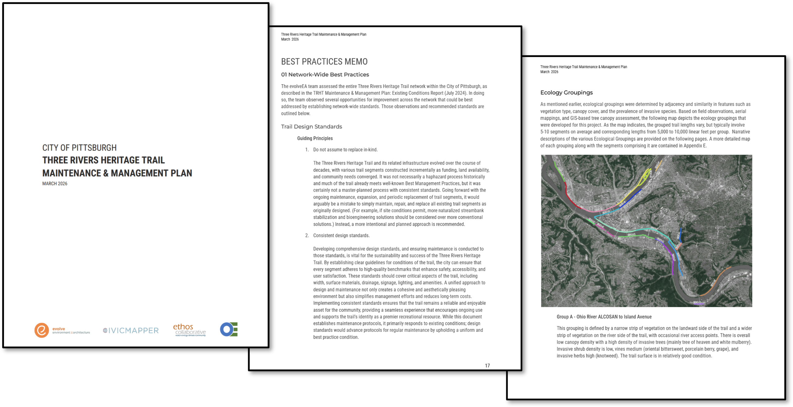
Purpose of the Plan
The City of Pittsburgh Department of Mobility and Infrastructure led a process to identify improvements to maintenance and management of the Three Rivers Heritage Trail (TRHT). The results of this process were documented in three deliverables: an existing conditions report, a best practices memo, and a recommendations report; these three elements compose the Maintenance & Management Plan. The plan is intended to guide DOMI, DPW, and partner agencies that steward the riverfront trail, helping to organize and streamline efforts to ensure the Three Rivers Heritage Trail remains one of the region’s most celebrated assets.
Final Plan Document Available for public comment!
Please click on the plan image below to view the plan or visit the document library where you can view the plan and appendices. The comment period will be open until June 1st, 2026. Comments can be submitted below.
As part of the Three Rivers Heritage Trail (TRHT) Maintenance & Management Plan, we have launched an interactive ArcGIS dashboard to provide a transparent, data-driven look at the current state of our trail network. This tool moves beyond static maps, offering a "virtual field area" that allows the city, stakeholders, and the public to explore trail conditions. This dashboard provides a comprehensive snapshot of the state of the TRHT at the time of the project.
Access the Interactive Map Dashboard Here
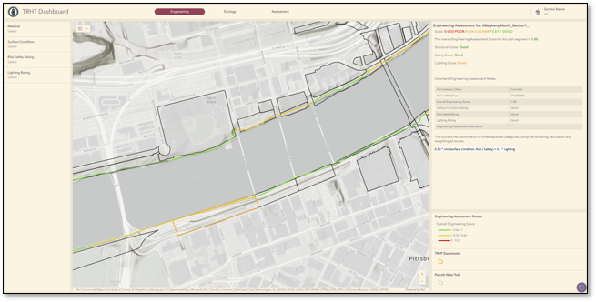
Whether you are a frequent trail user curious about trail conditions or a planning professional looking for technical data, this interactive dashboard provides a comprehensive window into the management of the Three Rivers Heritage Trail.
Project Goals
Improving Management & Coordination
- Defining Roles and Responsibilities: The plan aims to clarify which city departments and nonprofit partners are responsible for specific assets, such as trail surfaces, lighting, or vegetation
. This involves a detailed "roles and responsibilities matrix" to ensure no part of the trail is overlooked. - Clarifying Ownership: Because the trail spans various public and private properties, clearly identifying who owns each segment is essential for determining who must lead and fund maintenance efforts
. - Creating Accountability: By formalizing these roles, the plan creates a system where partners are accountable for the upkeep of their designated sections, ensuring consistent quality across the entire network
.
Operational Efficiency & Strategy
- Increasing Efficiency: The plan seeks to streamline maintenance by moving away from isolated, ad-hoc repairs toward a coordinated strategy that maximizes the use of labor and equipment
. - Prioritizing Investments: Using field data, the plan categorizes trail segments by risk and condition (e.g., "Poor Condition, High Risk") so that the most urgent safety and structural needs are addressed first
. - Implementing a Shared Capital Plan: A unified capital plan allows all stakeholders to see the "big picture" of upcoming major projects, helping them align their multi-year budgets and construction schedules.
Resource & Financial Planning
- Coordinated Fundraising: Instead of partners competing for the same grants, this goal encourages a "team approach" to seeking funds for large-scale trail improvements and ongoing maintenance
. - Supporting Staffing Plans: By understanding the full scope of work required (such as invasive species management), individual organizations can better plan their hiring needs and volunteer coordination
. - Protecting Investments: This goal focuses on proactive care to safeguard the millions of dollars and years of effort already spent building the TRHT, preventing minor issues from turning into costly structural failures
.
Enhancing the User Experience
- Ensuring a Safe, Connected, and Comfortable Network: The ultimate goal is to provide a seamless experience for all users by upholding high standards for safety, accessibility (ADA compliance), and trail conditions
. - Data-Driven Decision-Making: By prioritizing regular data collection (every 3-5 years), the city can use actual usage patterns and deterioration models to make smarter, long-term decisions about trail upgrades
.
Existing Conditions
The Existing Conditions Report provides a comprehensive, data-driven assessment of the Three Rivers Heritage Trail (TRHT) to establish a baseline for future maintenance and investment
Mobility Infrastructure
The trail surface and structures were meticulously cataloged to identify safety risks and repair needs
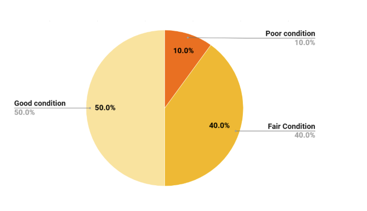
- Surface Condition: Detailed inventories were created for asphalt, concrete, and aggregate segments, noting specific defects like potholes, longitudinal cracks, and edge deterioration
. - Condition Ratings were assigned to each trail segment based on a specific set of criteria.
| Rating | Criteria |
| Good | No major faults; smooth and well-maintained surface. |
| Fair | Minor cracks and potholes (some may be filled), minor tripping hazards, or wayfinding issues. |
| Poor | Major cracks, uneven surfaces, significant tripping hazards, unfilled potholes, or wayfinding issues. |
- Structural Risks: The team identified the structural risk of each trail segment based on the "High Risk" areas where the trail is threatened by aging retaining walls, steep slopes, or unstable soils that could lead to landslides or collapses
. - Drainage Features: Assessments included identifying failed or missing drainage infrastructure, which is a primary cause of accelerated trail wear and tear
. - Trail Lighting: Much of the trail is unlit, or rated "poor" lighting condition, which is in keeping with its intended use as a daytime amenity.
Ecological Infrastructure
This assessment focused on the health of the "green" assets surrounding the trail, specifically within a 40-foot buffer on either side
Tree Canopy: The report identifies areas of sparse canopy to prioritize new tree plantings, which help mitigate urban heat and stabilize riverbanks. The Tree Canopy is sparse, with 79% of trail segments having low canopy density and 21% with medium density.
Invasive Species Management: Specialists rated the density of invasive trees, shrubs, vines, and herbaceous plants (like Japanese knotweed and Tree of Heaven) that compete with native wildlife habitat and can block scenic river views.
- Invasive shrub density is high in 40% of segments; the main species is Amur honeysuckle.
- Invasive herbaceous density is high in 62% of segments; the main species is knotweed.
- Invasive tree density is high in 31% of segments; the main species is tree of heaven, followed by white mulberry.
- Invasive vine density is high in 36% of segments; the main species is porcelain berry.
Riparian Zone Condition: A boat-based survey was conducted to evaluate the stability of riverbanks, noting where manmade structures or natural slopes require restoration.
Best Practices
The Best Practices Memo provides guidance for how to move away from historical, incremental construction toward an intentional, master-planned approach
Key Guiding Principles
- Move Beyond "In-Kind" Replacement: Future repairs should consider modern standards rather than just replicating original designs
. For example, bioengineering and naturalized streambank stabilization should be prioritized over conventional hard structures where site conditions allow . - Consistent Design Standards: Establishing uniform guidelines for width, materials, drainage, and signage simplifies management and reduces long-term costs
. - Universal Safety and Accessibility: All trail segments are intended to meet or exceed ADA (Americans with Disabilities Act) guidelines to ensure inclusive use for pedestrians, cyclists, and wheelchair users
. - Data-Driven Decision Making: The plan recommends re-assessing every trail segment in its entirety every 3–5 years
. This systematic data collection allows for "predictive maintenance" and more efficient resource allocation based on actual deterioration patterns .
| Category | Best Practice Overview |
| Trail Materials | Materials are selected based on intended use and traffic. High-commuter routes (e.g., Downtown to Hazelwood) should be smooth asphalt or concrete, while residential sections (e.g., Washington’s Landing) may remain aggregate. |
| Trail Width | Standard widths should accommodate diverse users and maintenance vehicles. Wider sections are recommended for sharp curves or areas with poor visibility to prevent collisions. |
| Fall Protection | High priority is placed on sections near steep slopes or failing retaining walls. The plan calls for regular safety audits and the installation of barriers or signage in high-risk zones. |
| Vegetation | Focuses on diverse, native plant communities that are resilient to future climate conditions. Invasive species (e.g., knotweed, tree of heaven) should be managed to prevent thickets that block views or damage trees. |
| "No Mow" Zones | Recommends replacing traditional mowed lawns with "no-mow" native grass and forb mixes to reduce maintenance frequency and support habitat. |
| Wayfinding | Recommends consistent naming conventions across the network and digital tools (like Google Maps) to reduce public confusion. It also suggests field-based segment markers to assist maintenance staff. |
Recommendations
The Recommendations Report serves as the actionable heart of the Three Rivers Heritage Trail (TRHT) Maintenance & Management Plan. It translates months of field data and stakeholder input into a clear, prioritized strategy for physical repairs and organizational improvements.
The report is divided into two primary areas: the Maintenance Action Plan, which addresses the trail’s physical needs, and the Management Plan, which outlines how the city and its partners will work together to get the job done.
The Maintenance Action Plan
The Maintenance Action Plan moves away from "reactive" repairs—fixing things only after they break—and toward a proactive and systematic approach.
- Priority Ranking by Risk: Every trail segment is assigned a priority level based on its condition and the potential risk to the public. "High Risk" segments—those with severe structural issues or significant tripping hazards—are prioritized for immediate engineering review and funding.
- Segmented Work Orders: By breaking the trail into 1,000 to 1,500-foot segments, the plan allows maintenance crews to target specific deficiencies. This ensures that resources are used efficiently rather than repaving large sections that may still have years of life left.
- Standardizing Maintenance Tasks: The report categorizes work into four distinct types to help different teams coordinate their efforts:
- Clean + Safe: Routine tasks like debris removal and minor surface repairs.
- Habitat: Management of invasive species and tree canopy health.
- Structures: Complex repairs to bridges, boardwalks, and retaining walls.
- Traffic: Maintenance of lighting, signage, and wayfinding.
The Management Plan
Maintaining a world-class trail network requires more than just asphalt and shears; it requires a coordinated organizational structure. The Management Plan outlines how to bridge the gap between "who owns it" and "who maintains it."
- Unified Roles & Responsibilities: The plan introduces a formal matrix that clarifies the roles of the Department of Mobility and Infrastructure (DOMI), the Department of Public Works (DPW), and nonprofit partners like Friends of the Riverfront. This eliminates confusion and ensures accountability.
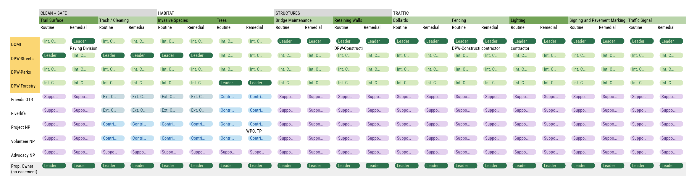
- Dedicated Trail Leadership: To ensure long-term success, the report recommends establishing dedicated roles, such as a Trail Manager and an Ecology Manager, to oversee day-to-day operations and coordinate multi-partner projects.
- Annual Trail Summit: A major recommendation is to convene an Annual Trail Summit or Trail Partners Meeting that brings all Trail Partners and other organizations involved in maintaining the trail together to prioritize capital planning work.
- Digital Asset Management: A major recommendation is the transition to a digital system for tracking maintenance. By using the tools developed during this study, the city can track the history of every trail segment in real-time, making it easier to plan budgets and apply for grants.
Implementation & Funding
The Recommendations Report provides the framework for a Shared Capital Plan. This allows all stakeholders to see a 3-to-5-year outlook of major projects, making it easier to:
- Align Budgets: Coordinate city funding with nonprofit fundraising.
- Secure Grants: Use the data in this report to provide "shovel-ready" evidence for state and federal grant applications.
- Monitor Progress: Establish a cycle where the trail is re-evaluated every few years to measure the impact of these recommendations and adjust the strategy as needed.
Map Dashboard
What You Can Explore
The dashboard integrates high-resolution drone imagery, and detailed field notes collected during the 2024 assessment. Users can toggle between different layers to view:
- Segment-by-Segment Conditions: View the trail divided into 1,000 to 1,500-foot sections, each with its own rating for surface quality and structural risk.
- Infrastructure Health: Identify the location and condition of asphalt, concrete, and aggregate surfaces, as well as critical "gray" infrastructure like retaining walls and drainage systems.
- Ecological Data: Explore the "green" infrastructure surrounding the trail, including tree canopy density and the presence of invasive species that impact the trail’s environment.
- Engineering Insights: For a deeper dive, the "Engineering" page highlights high-risk areas where surface defects correlate with underlying structural challenges, such as riverbank instability or aging walls.
A Tool for Proactive Management
This dashboard is more than just a map, it is a management priority tool. By centralizing data from diverse sources (including U.S. Army Corps of Engineers reports and boat-based riparian surveys), the City of Pittsburgh and its partners can:
- Target Investments: Visually identify "High Risk" segments that require immediate geotechnical or structural inspection.
- Coordinate Efforts: Ensure that all partners—from public works crews to nonprofit habitat restorers—are working from the same set of facts.
We want to hear what you think!
Have any feedback on the plan? Provide it here! (max 140 characters).


